

Champawat district is one of 13 districts of the state of Uttarakhand. The administrative headquarter is of the district is in Champawat town. It is in the eastern part of the Kumaon Himalayas at an average elevation of 1,615 meters, blessed with the extravagance of natural beauty. Dehradun to Champawat distance is 416 km. According to the Census 2011, Champawat dist is the second least populous region in the state of Uttarakhand. It is the smallest district in the state by area.
The district of Champawat is geographically divided into Tarai, Shivalik and high mountain ranges which are widely appreciated as the origin of culture and religion in Uttarakhand state. Today we will give you a glimpse of the Champawat dist. Here you will find a detailed guide on tourism, weather, education, distance, route map and places to visit in Champawat district.
Champawat at a Glance
| Headquarter | Champawat |
| Popular Places | Purnagiri, Lohghat, Pancheshwar |
| District Magistrate | Surendra Narayan Pandey (IAS) |
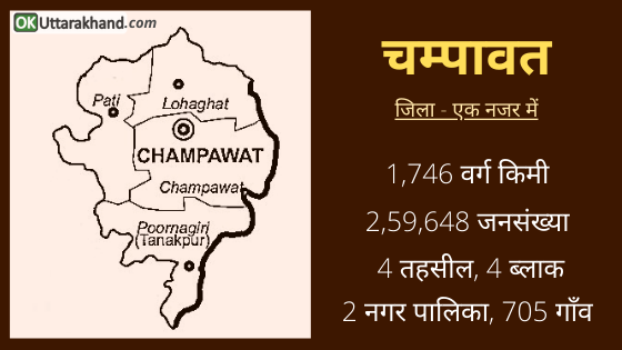
| Area | 1766 sq km |
| Tehsils | 7 (including 2 Sub-Tehsil) |
| Villages | 705 |
| Population (2011) | 2,59,648 |
| Vehicle Registration | UK-03 |
| STD Code | 05965 |
| Pin Code | 262523 |
| Official Website | https://champawat.nic.in |
History of Champawat District
Champawat district gets its name from princess Champawati. She was the daughter of King Arjun Deo who ruled the region in historic time. Champawat was formerly the capital of the Chand dynasty and other rulers of Kumaon Kingdom. From ancient to modern, We will talk about Champawat history in this section. Let’s start with the mythological beliefs and ancient history of Champawat district.
Ancient History: The folklores describe the significant presence of the region during the Mahabharata period. Mahabharata dates back to Dwapar Yuga when Lord Vishnu had incarnated as Lord Krishna and supported Pandavas in the holy war at Kurukshetra. Maa Barahi temple of Devidhura, Hidimba-Ghatotkach ‘Ghatku’ temple, Sapteshwar temple and Tarkeshwar temple of Champawat town are believed to date back to Mahabharata era.
The region of Champawat is traditionally associated with gods and demons and as the place of penance for rishis (Hindu ascetics). The area covered by the district lies in the part of Central Himalayas, which is designated as the Manas-Khand (section) of the Skand Purana as one of the five divisions of the Himalayan region. Champawat has also been known at different times by the names of Kiratamandala, Khasadesha, Kalindavishaya, Kurmanchala, and Kurmavana.
Many legends are associated with different places, mountains, rivers, forests, and temples in the district. In order to save the earth, Lord Vishnu in his second incarnation assumed the form of the Kurma (Tortoise) and remained standing for three years at a particular spot in the Chamoli district. The specific rock on which the God stood came to be known as ‘Kurmashila’, the entire hill as the Kurmanchal and the surrounding forest as Kurmavana. The name Kumaon is supposed to have been derived from these ancient terms. The region covered by Champawat district was also known as ‘Kali Kumaon’ for a long time. This term ‘Kali Kumaon’ came from the river Kali which flows through Kumaon.
During the medieval period, when the power of the Chand Kings of Champawat expanded rapidly the name Kumaon gradually came to denote the entire region extending from the snow ranges in the north to the Tarai in the south.
After the Mahabharata war, the district seems to have remained for some time under the sway of kings of Hastinapur. The actual rulers were the local chiefs of whom the Kulindas (Kuninda Kingdom) were probably strong. Subsequently, the Naga dynasty appeared to have held dominion of the district. It appears that for centuries a number of local Patti chiefs mostly Khasas or Kulindas continued to rule over the different parts of the district.
1st – 5th Century: The earliest coins discovered in the district bear the name of rulers – Kuninda Kingdom. During the last quarter of the 1st century AD, the Kushan empire extended over the western and central Himalayas. But about the 2nd quarter of the 3rd century, the empire of the Kushans crumbled down. This area was ruled by the Nanda kings of Magadh from the 4th to 5th centuries.
6th – 9th Century: Chinese pilgrim Hiuen Tsang (Xuanzang) visited the present area of the district during the summer of 636 AD. After the decline of the Katyury dynasty, Chand Rajputs were destined to reunite the whole of Kumaon under one rule. At this juncture, a Chandravanshi Rajput prince named Som Chand constructed his Rajbunga Fort and later named as Champawat.
The year 953 AD has been suggested as the most probable date for the beginning of his reign in the district. Som Chand is said to have ruled for about twenty years till 974 AD. Later on, entire territory ok Garhwal and Kumaon were divided into a number of small Patties (more than 52) and each of them being under a semi-independent ruler.
According to tradition, King Brahmadeva was a saintly King and a weak ruler. He was the Katyuri raja (Hindu ruler) of Kali Kumaon. He was troubled by the insubordination of the Rawat of Domkot (now Dhumakot) and also found himself unable to suppress the formidable factions among his own people. He was succeeded by Som Chand (Chandravanshi Rajput), who married the daughter of the raja.
Som Chand built his fort here on 15 acres of land. Som Chand was succeeded by his son, Atma Chand who continued the work of consolidating the power and influence of the small kingdom. It is said the rulers of all the neighboring Patti states paid court to him at Champawat. The Baleshwar Temple built by the Chand rulers in the 12th century is an excellent monument with marvelous stone carving works.
His son Puran Chand spent much of his time in hunting. And the latter’s son and successor Indra Chand is credited with importing silkworms into Kali Kumaon, probably from Nepal. And thus introducing the manufacture of silk in these parts.
Modern History: They followed Sansar Chand, Sudha Chand, Hari Chand, and Bina Chand one after the others up to the years 1725 and King Devi Chand was the last raja.
In 1726, King Devi Chand was assassinated by an agent of his own wily minister in his pleasure house. Thereafter, the two Gaira Bisht assumed full control of administration and were free to enjoy the power they had so criminally acquired.
On December 2, 1815, the entire Kumaun Kingdom was ceded to the British India.
About the beginning of the 20th Century, the inhabitants of the district began to become gradually conscious of their civic rights. They took part in the annual sessions of the Indian National Congress.
On 15 August 1947, the area was declared independent of British domination along with the rest of the country.
Formation of Champawat District
- Champawat district was formerly a part of the Almora district until 1972.
- After 1972, Champawat was the tehsil that came under the Pithoragarh district.
- Champawat was declared an individual independent district in 1997.
On 15 Dec 1997, the Government of Uttar Pradesh declared Champawat as a separate district. which was carved out from the Pithoragarh district.
Demographics
This space highlights the facts about Champawat district. Here you will find answers to some FAQ such as what is the population in Champawat? how many tehsils in Champawat? and other details about Caste, Religion, Culture & languages in the Champawat district.
Champawat District Population
Champawat district is the 2nd least populous of the 13 districts of Uttarakhand, after Rudraprayag district. According to the 2011 Census,
- Champawat district has a population of 259,648.
- Champawat district has a gender ratio of 980 females for every 1000 males.
- There is a literacy rate of 79.83% in Champawat district.
Culture & Languages in Champawat
Champawat is valued as the place of origin of culture and religion in the Uttarakhand region. This region is considered to be the home of Naga and Kinnar described in Hindu mythology.
The region was ruled by many kings in the past. Historical pillars, monuments, manuscripts, temples and folklore of the region are the evidence to its historical importance. The manuscripts make it clear that the Katyuri dynasty ruled the region in the past.
Champawat district maintains its flavor in language, culture, and tradition. The major first language of the district is Kumaoni. Hindi used as a lingua franca in the district.
Religion in Champawat District
As of the 2001 Indian census, the Champawat district had a population of 259,648. Hindus are in majority in the district. Other communities are Muslims, Christians, Sikhs, and Buddhists.
- Hindus (96.12 %)
- Muslims (3.35 %)
- Others (0.53 %)
Administration (Champawat District)
Champawat district administrative headquarter is in the town of Champawat. The district of Champawat constituted in the year 1997. It is one of the smallest districts of Uttarakhand. It is a part of the eastern Kumaon division of the state.
- It is bounded on the north by the Pithoragarh district.
- on the east by Nepal.
- on the south by Udham Singh Nagar district.
- on the west by the Nainital district.
- and on the northwest by Almora district.
Champawat district is divided into 7 tehsils (including 2 Sub-tehsil), 4 subdivisions and 4 blocks. The district covers 705 Villages and 2 Municipalities (Nagar Palika Parishad).
Tehsils in Champawat district
Champawat district has 7 Tehsil in which 2 are Sub-Tehsil. All Tehsils names are as follow:
- Pati
- Shri Poornagiri
- Lohaghat
- Champawat
- Barakot
- Pulla
- Munch
Sub-divisions in Champawat district
There are 4 Sub Division in Champawat district. All names are as follow.
- Pati
- Shri Poornagiri
- Champawat
- Lohaghat
Blocks in Champawat district
There are 4 blocks in in Champawat district. All blocks name are as follow.
- Lohaghat
- Champawat
- Pati
- Barakot
Constituencies in Champawat district
There are 2 Assembly constituencies in Champawat District that are; Lohaghat and Champawat.
There is one (1) Parliamentary Constituency in Champawat district that is Almora.
Education in Champawat District
The people of the Champawat district are well educated. The literacy rate is 79.83% in the district of Champawat which is higher than that national average of 74.04%. There are enough government and private schools to pursue school education. But there are few degree colleges that is why many students migrate to cities like Dehradun, Haridwar, Haldwani to complete their higher education.
Some of the other Colleges and Institutes in Champawat district are listed below.
- Government P.G. College Champawat
- Government P.G. College, Lohaghat
- Government Polytechnic, Lohaghat
- Government Polytechnic, Champawat
- Govt Degree College, Tanakpur
- Swami Vivekanand Govt P. G. College, Lohaghat
- Devbhumi College of Education, Champawat
Tourism in Champawat
This space highlights the tourism in Champawat district. It also displays the information such as the best places to visit near Champawat, temples in Champawat, trekking in Champawat, hill stations, and other activities at tourist places in Champawat.
Champawat is a famous tourist destination and was also once the capital of the Chand rulers. It has enormous religious significance as well. Champawat is a destination that attracts many pilgrims due to the sheer number of temples located in the region. These temples are beautifully constructed and carved, and some of them date back to the time of the Chand rulers.
These monuments are the greatest attractions for tourist peoples nowadays. Baleshwar, Devidhura, Pancheshwar and Poornagiri Temple are few such architectural building which built by the Chand dynasty. Champawat district has a wide density of dark forests which is a habitat center of millions of wild animals. Jim Corbett’s book, “man-eaters of Kumaon” is merely related to the wildlife that he sawed and experienced in Champawat.
Places To Visit in Champawat
There are a number of tourist destinations and places to visit in the Champawat district.
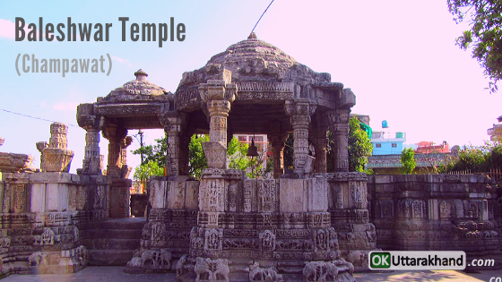
Baleshwar Temple: Baleshwar Temple is dedicated to Lord Shiva and it is the best temple in Champawat district in terms of art. This temple group situated in the middle of the city has many other idols besides Shiva, like Maa Bhagwati, Champa Devi, Bhairav, Ganesh, Maa Kali, etc. This group of temples was built by the Chand Kings in 1272. The carving of this temple displays the artistic grandeur of the time.
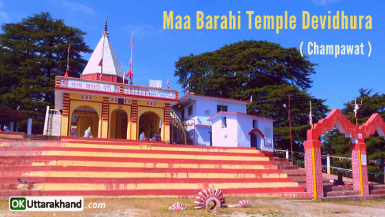
Maa Barahi Temple: Champawat is known for its Barahi temple which is situated at Devidhura. It has culture heritage of Bagwal festival and commonly practiced on the day of Raksha Bandhan. Bagwal stone pelting festival held in Champawat every year. This festival is a part of a ritual to appease a local deity. This unusual fair attracts people from Kumaon and Nepal. Bagwal festival held every year at the temple of Barahi Devi on Raksha Bandhan day. The famous writer Jim Corbett’s book ‘Temple Tiger’ is associated with Devidhura Temple.
Nagnath Temple: Nagnath Temple is dedicated to Lord Shiva. It is one of the finest example of Kumaon architecture. It’s a very antique temple, an old historical monument. This peaceful place is a must-visit while in Champawat. Nearby temples of Bhairav Devta and Shani Dev situated near to palace of Chand density.
Ek Hathiya Naula: Ek Hathiya Naula is one of the showcase master craft, which is formed by one artisan in one night. A simple yet majestic spot near Champawat at Dhakna village. A trail of about 2-3 km leads you to the Naula which literally means natural spring water. The hike is an easy to moderate level of difficulty. Champawat to Ek Hathiya Naula distance is 5 km.
Gatku Temple: It is believed that the head of ‘Ghatotkacha (son of Bhima and the Rakshasi Hidimbi) fell here after he died in the battle of Mahabharata. The Gahtku Mandir also known as Hidimba Devi & Ghatotkach Temple is the temple dedicated to Ghatotkacha. It is located 2 km away from Champawat in Taamli/ Chauki road. It is also one of the oldest temples in Champwat district.
Kranteshwar Mahadev: Kranteshwar Mahadev is located in the middle of the forest and the highest point of Champawat city. A view of another city Lohaghat is also visible from here. Kranteshwar Mahadev is far from city voice and the best place in Champawat to see the whole view of Champawat. You can see Himalayan hills from here. Kranteshwar Temple is also called Kurmapad or Kandev. It is one of the best sites for adventure and tracking in Champawat.
Lohaghat: Lohaghat is a small town in the Champawat district of the Kumaon region of Uttarakhand. Lohawati river meanders between its rocky banks. During the summers Lohaghat is draped with a carpet of red as the famed Rhododendrons bloom in all their splendor. Lohaghat is one of the unexplored hill station destinations of Uttarakhand. Champawat to Lohaghat distance is 14 km.
Gurudwara Shri Reetha Sahib: Guru Nanak Dev is said to have visited this place. The environment and surroundings at Gurdwara Reetha sahib are so calm that you forget about your worldly worries. In the courtyard of the gurudwara, there is a tree of Sweet Indian Soapberry.
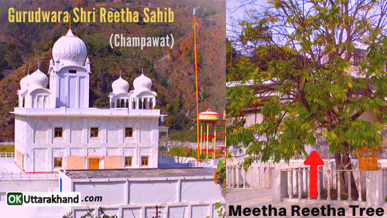
Reetha Shahib is located at the confluence of the rivers Ludhia and Rathia near Deori village. Two routes are available, one is via Tanakpur and another via Haldwani. The route via Tanakpur has an added advantage that u can visit Gurdwara Nanak Matta also. Gurudwara Reetha Sahib is located at a distance of 70 km from Champawat.
Purnagiri Temple: Purnagiri Temple has a natural beauty all along the way when you start your journey from Tanakpur to the temple. Purnagiri is one of the Siddh Peeth in India. It is said that the naabhi (Navel) portion of Maa Sati was fallen at top of Annapurna Parvat while she was carried by Lord Shiva. The temple area is surrounded by the River Kali or River Sharda. It has almost a 3 km trek to climb up the Purngiri hills. Tanakpur to Purnagiri Temple distance is 21 km. There is a major fair-like festival celebrated in Purnagiri Temple in the month of March-April Navratri season.
Advaita Ashrama, Mayavati: Swami Vivekananda visited Advaita Ashram and meditated at this place in 1901. After this visit, he decided to shift his publication office “Prabuddh Bharat” from Madras To Mayavati Ashram. This is a must-visit place for people who do yoga and meditation. A beautiful garden and a library dedicated to literature and spirituality are there. A must visit place in the Lohaghat. Located in the forest-covered with oak and deodar trees. Lohaghat to Advaita Ashram distance is 10 km. People can purchase books from Advaita ashram stores.
Abbot Mount: Abbott Mount is one of the most beautiful hill stations in the middle of a forest surrounded by Deodar trees. All the highest mountain peaks (Nanda Devi, Trishul, Neelkanth, Maktoli, etc.) of Uttarakhand are easily visible from here. A place with 180-degree visibility of Himalayas. Hilltop with a valley filled with a variety of trees and species of birds seen nowhere. Britisher’s built their colonies and established a hospital known as Abbey hospital here. It was the only hospital in the locality at that time. Abbott Mount is still unexplored and non-commercial there are only a few local caretakers of private property and guest house. One must plan to this destination who really likes to feel and enjoy the true nature.
Vanasur’s Fort or Banasur ka Kila: Banasur Fort is situated at the height of 1,754 m. Banasur was a man with a thousand arms. Banasur ka Kila was constructed in the memory of Banasur, the eldest son of the mythologically famous King Bali. He was assassinated here by Lord Krishna when Banasur had tried to kill Krishna’s grandson Aniruddha. Banasur Fort gives the perfect spot to watch the beauty of nature and the Himalayan ranges. Good location for a view from the hilltop. To reach the top there is a trekking of around 1.5 km. Once you reach the top you will have mesmerizing views of the Himalayas and the nearby places.
To reach the fort, you must journey to Lohaghat, about 20 km from Champawat and from Champawat to Karnakarayat which is about 6 km from Lohaghat, and then it’s a kilometer long walk to Banasur ka Kila. You will see the beauty of nature here.
Pancheshwar: Pancheshwar is situated at a distance of 40 km from Lohaghat, near the confluence of Saryu and Kali Rivers. This place shares its border with Nepal and is known for its Chaumu Temple, where local inhabitants worship the Jaat of Chaumu as a shield of the animal. Travelers can also visit Chamdeval (8 km), Rasul (12 km) and Pullu (5 km) that are prominent tourist sites from Pancheshwar. Champawat to Pancheshwar distance is 40 km.
Shyamlatal: Shyamlatal is a natural lake situated at an altitude of 1500 meters in Sarda valley in a village of Champawat district. “Shyam” means dark complex colors are used to describe Lord Krishna in Hinduism. Shyamalatal is on the path of Pithoragarh in the Champawat district of Uttarakhand. Vivekanand math located near Shyamlatal.
There is a Ramakrishna Mission Ashram, called Vivekananda Ashrama is within 1 km from here. This place is a great place for all spiritual seekers and nature lovers. 100 years ago the name of the Lake was given as Shyamalatal by Swami Birajananda, the 6th president of Ramakrishna Mission. He was one of the sanyasi disciples of Swami Vivekananda. Swami Virjanandaji did his sadhana here. Shyamlatal is a place for spiritual practices.
Weather in Champawat Dist
Champawat district is situated between 200-2000 meters above sea level. So there are different types of climate and weather in different heights.
Summer: 20°C to 34°C
Winter: 3°C to 22°C
Champawat district usually enjoys a more moderate climate throughout the year. The average temperature for the year in Champawat is 24.6 °C.
The warmest month is June with an average temperature of 32.1 °C.
The coolest month is January with an average temperature of 14.3 °C.
Best Time To Visit Champawat
The best time to visit Champawat is in the month of April to June. The min and max temperature in April in Champawat is 15°C and 23°C respectively. The weather and climate remains generally pleasant and clear in April and you would feel good throughout the day
How To Reach Champawat
The Champawat district is well connected by the roadways with neighboring districts that connect it with the rest of the Uttarakhand, the rest of India and even the neighboring country Nepal through Tanakpur. Pantnagar airport Udhamsingh Nagar is 169 Km from Champawat. One can begin his journey to Champawat in bus, taxi or jeep from Pantnagar airport. Tanakpur Railway Station in Champawat is 75Km away from Champawat town. Tourists can begin to their destination through roadways, private taxi from Tanakpur railway station.
How To Reach Champawat by Air
The nearest airport to Champawat is Pantnagar Airport situated in the US Nagar, Uttarakhand state. Taxis are available from Pantnagar Airport to Champawat. Pantnagar is connected to Delhi and Dehradun with daily flights. Pant Nagar Airport is well connected by motorable roads with Champawat. Pantnagar to Champawat distance is 169 km. Another option is Naini Saini Airport which is situated in Pithoragarh but flights are not very frequent to Naini Saini Airport.
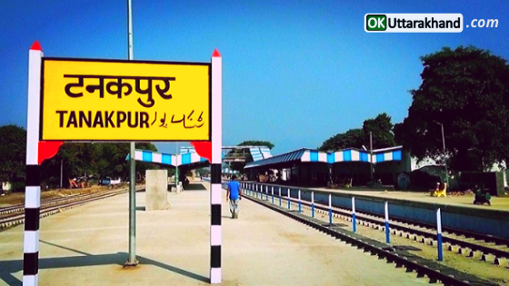
How To Reach Champawat by Train
The nearest railhead to Champawat is Tanakpur Railway Station. Tanakpur to Champawat distance is 73 km. Private taxis and roadways buses are easily available from Tanakpur Railway Station to Champawat city. Tanakpur is well connected with major destinations of India like Lucknow, Delhi, Agra, Haridwar, Saharanpur, and Kolkata. Trains are frequent to Tanakpur Railway Station and you can reach Champawat from Tanakpur by road via taxi.
How To Reach Champawat by Road
Champawat district is well connected by motorable roads with major destinations of Uttarakhand state and northern India. Buses from ISBT Anand Vihar (New Delhi) are easily available to Tanakpur and many other destinations. After reaching Tanakpur, you can easily hire a local cab or bus to reach Champawat. Private taxis and UTC roadways buses are easily available to Champawat from major destinations of the Kumaon region. You can reach Champawat from Tanakpur by road following the National Highway NH-125.
Champawat Distance from Major Cities
⦿ Delhi to Champawat (422 km)
⦿ Dehradun to Champawat (416 km)
⦿ Chandigarh to Champawat (631 km)
⦿ Hyderabad to Champawat (1718 km)
⦿ Bangalore to Champawat (2308 km)
⦿ Ahmedabad to Champawat (1335 km)
⦿ Mumbai to Champawat (1626 km)
⦿ Rishikesh to Champawat (383 km)
⦿ Agra to Champawat (426 km)
⦿ Varanasi to Champawat (674 km)
⦿ Amritsar to Champawat (836 km)
⦿ Gurgaon to Champawat (432 km)
⦿ Jodhpur to Champawat (990 km)
⦿ Shimla to Champawat (729 km)
⦿ Jaipur to Champawat (662 km)
⦿ Manali to Champawat (926 km)
⦿ Kolkata to Champawat (1345 km)
⦿ Chennai to Champawat (2341 km)
⦿ Udaipur to Champawat (1052 km)
⦿ Haridwar to Champawat (363 km)
⦿ Pune to Champawat (1667 km)
Important Links:
Official Website of Champawat dist: https://champawat.nic.in
Advaita Ashram Website: https://advaitaashrama.org
Government Polytechnic, Lohaghat: www.gplohaghat.org.in
Govt Degree College, Tanakpur: www.gdctanakpur.com
Swami Vivekanand Govt P. G. College, Lohaghat: www.svpgcollege.org.in


